07 Applied Hydrogeology
07-03 Groundwater in Water Supply
Well fields, superposition principles, collector wells, design problems.
Contents
| Index | Description |
|---|---|
| 07-03-001 | Well Capture App |
07-03-001Well Capture App
| Type: Streamlit app | Time: 15–30 minutes |
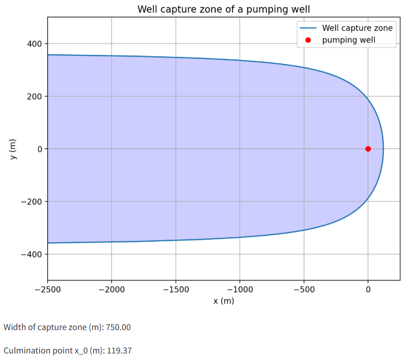
Figure 1: The computed well capture zone (Screenshot)
This interactive app visualizes the well capture zone (capture width and dividing streamlines) for a single pumping well in a confined aquifer subject to regional uniform groundwater flow.
Users adjust the pumping rate, hydraulic conductivity, aquifer thickness, and regional hydraulic gradient (with log-scaled sliders) and immediately see how these parameters control the shape and extent of the capture zone in plan view.
In addition to plotting the separating streamlines, the app reports two key diagnostic quantities: the total capture-zone width 2y_max and the culmination point x_0, which together provide a compact characterization of the contributing area feeding the well under steady-state conditions.
This tool supports conceptual understanding of wellhead protection and capture-zone sensitivity in confined aquifers and complements the theory section of the multipage well-capture module.
| Detail | Value |
|---|---|
| URL | gwp-wellcapture.streamlit.a… · open app |
| Author(s) | Thomas Reimann (TU Dresden) |
| Keywords | well capture, capture zone, water protection zone, well catchment |
| Fit For | self learning, online teaching, classroom teaching |
| Prerequisites | Basic hydrogeology, Aquifer parameters |
Streamlit app details
| Detail | Value |
|---|---|
| Multipage app | yes – approx. 4 page(s) |
| Interactive plots | 1 interactive plot(s) |